Target 15A
By 2030, a 15 per cent increase in Australia’s land mass subject to Aboriginal and Torres Strait Islander people’s legal rights or interests.
Target 15B
By 2030, a 15 per cent increase in areas covered by Aboriginal and Torres Strait Islander people’s legal rights or interests in the sea.
Dashboard snapshot: The data below are the most recent at the time of preparing the July 2022 report. Please go to the dashboard to access the current data.
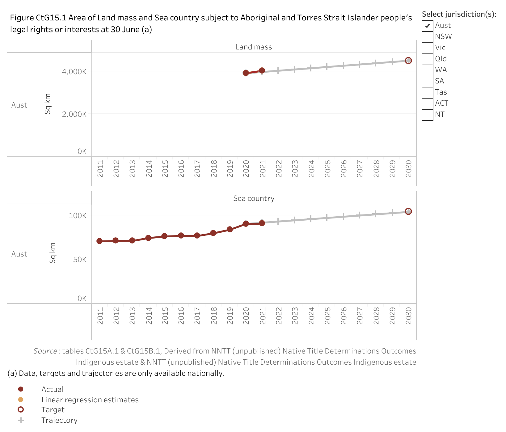
In 2021, 4 027 232 square kilometres of the land mass of Australia and 90 555 square kilometres of the sea country of Australia were subject to Aboriginal and Torres Strait Islander people’s rights or interests (figure CtG15.1).
Nationally, based on progress from the baseline, the land mass target shows good improvement and is on track to be met, while the sea country target shows improvement but is not on track to be met. However, these assessments should be used with caution as they are based on a limited number of data points. Please see the How to interpret the data page for more information.
| NSW | Vic | Qld | WA | SA | Tas | ACT | NT | Aust | |
|---|---|---|---|---|---|---|---|---|---|
| Assessment of Land mass | |||||||||
| Assessment of Sea Country | Not applicable as required data not available |
improvement
no change
worsening not applicable as required data not available.
good improvement and target on track to be met.
improvement but target not on track to be met.
Note: These assessments of progress should be used with caution as they are based on a limited number of data points.
Target data specifications
Outcome: | Aboriginal and Torres Strait Islander people maintain a distinctive cultural, spiritual, physical and economic relationship with their land and waters. |
|---|---|
Target: | By 2030, a 15 per cent increase in:
|
Indicator: | Area of Australian land mass and sea waters that is subject to Aboriginal and Torres Strait Islander people’s legal rights or interests. |
Measure: | This measure is defined as: a: Land mass subject to Aboriginal and Torres Strait Islander people’s legal rights or interests, at 30 June b: Sea Country subject to Aboriginal and Torres Strait Islander people’s legal rights or interests, at 30 June. |
Target established: | National Agreement on Closing the Gap July 2020 |
Latest dashboard update: | 31 March 2022 |
Indicator type: | Target |
Interpretation of change: | A high or increasing area is desirable. |
Data source(s): | Name: Native Title Determinations Outcomes; Indigenous estate Frequency: Annual (revised data for 2020 in the March 2022 Dashboard update). Documentation (links): http://www.nntt.gov.au |
Data provider: | Provider name: National Native Title Tribunal (land and sea native title) Provider area: Native Title |
Baseline year: | 2020 |
Latest reporting period: | 2021 |
Target year: | 2030 (at 30 June) |
Disaggregations: | State and territory and Australia. Support measure provided on native title as proportion of jurisdiction’s land — state, territory and Australia. |
Computation: | Counting rules Land area Land under Aboriginal and Torres Strait Islander legal rights or interests includes:
Land area is in square kilometres (sq km) and has been calculated using GDA2020 (EPSG 7844). Pre-2016 areas are calculated using Australian Albers projection (EPSG 3577). Proportion of land area is based on jurisdiction area sourced from Geoscience Australia (1993). (http://www.ga.gov.au/scientific-topics/national-location-information/dimensions/area-of-australia-states-and-territories). Data for the ACT includes Jervis Bay. Sea area Sea area is in square kilometres (sq km) and is based on approximate jurisdiction areas sourced from maritime boundaries spatial data, Geoscience Australia 2006 (AMB 6th Edition). Commonwealth jurisdiction area only consists of that area from the 3NM Limit out to the Exclusive Economic Zone surrounding the mainland states and territories. It does not include the area surrounding the islands of McDonald & Heard, Christmas, Macquarie, Norfolk, Cocos (Keeling) or the Australian Antarctic Territory. |
Data quality considerations: | Data are available at other points in time (available on request, obtained from automated processes but are not quality assured by the National Native Title Tribunal for reference dates other than 30 June). |
Supporting indicators
Driver
- Aboriginal and Torres Strait Islander people’s owned land and water titles
- Number of land claims resolved under Commonwealth, state and territory land rights legislation
- Number of positive Native Title Determinations
Contextual information
- Number of Indigenous Land Use Agreements (ILUAs) on the Register of Indigenous Land Use Agreements
- Income of registered native title bodies corporate as reported to the Office of the Registrar of Indigenous Corporations (ORIC)
Including income from businesses or grants
- Charitable trusts holding native title and land rights monies
- Number of Aboriginal and Torres Strait Islander people employed in water and land management
- Australia’s conservation estate that is managed by Aboriginal and Torres Strait Islander people
- Proportion of Aboriginal and Torres Strait Islander people who recognise and live on homelands/traditional country
Material for download
- People maintain a distinctive cultural, spiritual, physical and economic relationship with their land and waters data tables (XLSX - 41 Kb)
- People maintain a distinctive cultural, spiritual, physical and economic relationship with their land and waters dataset (CSV - 60 Kb)
To assist with interpretation of the data provided (Excel data tables and CSV dataset) please refer to the target data specification (above) and the indicator data specifications (provided in each supporting indicator page – linked above).
